The world’s dependence on the ocean for sustenance, energy, and commerce is on the rise, yet a significant portion of human activities at sea remains unquantified. A recent study -published in the journal Nature- employing satellite imagery, vessel GPS data, and deep-learning models, has shed light on the scope of industrial vessel activities and offshore energy infrastructure from 2017 to 2021.
The research uncovered that 72–76% of the world’s industrial fishing vessels operate untracked, with substantial activity observed around South Asia, Southeast Asia, and Africa. Furthermore, 21–30% of transport and energy vessel activities are missing from public tracking systems. The study also noted a 12% decline in global fishing at the onset of the COVID-19 pandemic in 2020, which had not fully recovered by 2021. In contrast, transport and energy vessel activities showed resilience during the same period.
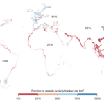


High-resolution mapping reveals detailed patterns of fishing activity not publicly tracked

The growth of offshore wind, surpassing the number of oil structures in 2021, is highlighted in the study. The ‘blue economy,’ valued at 1.5–2.5 trillion dollars, is a rapidly expanding sector with implications for global trade and energy production. However, this growth is accompanied by environmental challenges, including overfishing and habitat loss.
The study addresses the lack of comprehensive global observational data on ocean expansion and emphasizes the role of satellite imagery and deep learning in improving monitoring capabilities. The researchers utilized over 2 petabytes of satellite imagery from 2017 to 2021, covering more than 15% of the ocean, to create a detailed global map of major industrial activities at sea.
The findings reveal concentrated vessel activity, with Asia accounting for 67% of all vessel activity, followed by Europe, North America, Africa, South America, and Australia. The mapping also identifies potential hotspots of illegal fishing activity, such as the western part of the Korean Peninsula, and highlights vessels operating inside marine protected areas.
Additionally, the study provides insights into changes in vessel activity over time. It also examines the distribution and growth of offshore structures, including wind turbines and oil structures.
The study reveals the extent of major industrial activities at sea, with fishing being by far the ocean industry with the most activity that is not public. The free dataset and technology, hotspots of potentially illegal activity and industrial fishing vessels can be identified that are encroaching on artisanal fishing grounds or other countries’ EEZs, but at a global scale and accessible to any nation.
Maps of global fishing effort can now include all vessels, not just those based on AIS tracking (which misses about three-quarters of large vessels), and with much higher resolution than just EEZs or statistical reporting areas. The data can also help to quantify the scale of greenhouse gas emissions from vessel traffic and offshore development, which may help to inform policies on reducing greenhouse gas emissions.
The observed changes in human activity in the ocean provide a snapshot of the evolving industrial use of marine resources. While the COVID-19 pandemic played a significant role in reducing fishing activity, it decreased more substantially than other ocean industries. This decline aligns with a long-term trend indicating a diminishing importance of fishing in the ocean since the 1980s. Despite a several-fold increase in global marine fish catch since 1950, recent years have only seen a slight uptick in overall fishing effort.
Notably, countries implementing fishery reforms have experienced an actual decline in fishing activity. This suggests that the highlighted decrease may signify a broader, longer-term trend, possibly indicating the peak of fishing activity in the past decade. On the other hand, the study suggests that transport and energy vessel traffic is likely to continue expanding, driven by global trade trends and the rapid growth of renewable energy infrastructure. The potential impact of these changes on marine ecosystems, comparable to the effects of fishing, underscores the need for accurate mapping of these activities to better comprehend and manage future human engagements in the ocean, particularly in the face of ongoing industrialization and environmental challenges.
Source: Nature